- Geology
- Physics
Flight paths are not evidence for a flat Earth
Key takeaway
There is overwhelming evidence that Earth is a round planet. However, it’s impossible to accurately represent a globe’s 3D surface as a flat 2D map without distorting it. Mapmakers must choose a projection – a way of distorting the globe. The map shown in the video uses a projection that distorts the directions between points outside the center, making Auckland, San Francisco, Houston, and Buenos Aires erroneously appear aligned. This is not evidence for a flat Earth.
Reviewed content

Verdict:
Claim:
Flights from New Zealand to Argentina connect through the U.S., which only makes sense if the Earth is flat.
Verdict detail
Misleading:
The video relies on a map projection that distorts directions to make Auckland, San Francisco, Houston, and Buenos Aires appear to form a nearly-straight line. On a globe, this is false.
Misleading:
The video chooses one particularly roundabout flight route from New Zealand by way of the U.S. to Argentina, ignoring the facts that a more direct route has existed in the past and that similar routes from Australia to Chile exist today.
Full Claim
We can make it from New Zealand to Argentina on one flight. But, on United Airlines, we have Auckland going to San Francisco, San Francisco to Houston, Houston finally into Buenos Aires. Why? That seems like it would be a waste of gas. But on the flat Earth model, they form a straight line. You would be able to make it on one tank of gas.
Review
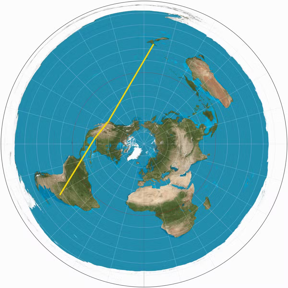
On 14 February 2025, a Facebook user posted a video that has since collected nearly 200,000 views. The video features a person searching for flights from Auckland, New Zealand, to Buenos Aires, Argentina. Not finding a direct route, the person instead chooses a roundabout route consisting of three flights: Auckland to San Francisco, San Francisco to Houston, then Houston to Buenos Aires. The video pinpoints these cities on a circular map to show that they apparently form a straight line (Figure 1).
The video claims this alignment – and the lack of a direct flight from Auckland to Buenos Aires – as evidence for a flat Earth. We’ve previously covered several flat Earth claims – there is overwhelming evidence that the Earth is a round planet. The alignment depicted in the video is not proof of a flat Earth, but instead the result of a map projection that distorts the directions between points to make the four cities appear to line up. We explain below.
Flights between Argentina and New Zealand are possible and have existed in the past
It’s perfectly possible to fly between South America and the South Pacific on ‘one tank of gas’ (or, more accurately, a single load of jet fuel).
Although no direct flights link New Zealand and Argentina today, such flights existed quite recently: Air New Zealand operated flights between Auckland and Buenos Aires before the Covid-19 pandemic. And other flights exist on similar routes between South America and the South Pacific: LATAM and Qantas both offer direct flights between Sydney, Australia and Santiago, Chile.
Simply because an airline route can exist does not mean it will exist. A route requires enough demand to be viable. If transoceanic flights aren’t common in the Southern Hemisphere, it’s because only one-eighth of Earth’s population lives south of the equator[1]. The Southern Hemisphere also has less of the supporting infrastructure that modern flights require. Norwegian reportedly planned flights between Buenos Aires and Perth, Australia, on a southern polar route over Antarctica, but scuttled the plans because Antarctica has few alternate airports where a plane could land in case of emergency.
Additionally, most airlines run their flights through hub airports in their own country. The video only shows United Airlines flights. United is headquartered in the U.S., not in Argentina or New Zealand. It makes sense, then, that flying United from New Zealand to Argentina would involve connecting at U.S. airports like San Francisco and Houston, both of which are United hubs.
Auckland, San Francisco, Houston, and Buenos Aires only line up due to the map’s projection
As we explain here, there is overwhelming evidence that Earth is a near-spherical globe: climate patterns, Earth’s magnetic field, the shadow that Earth casts on the moon, photos of the spherical Earth taken from space, and more. But representing the 3D surface of a globe as a flat 2D map with complete accuracy is impossible, so mapmakers have to choose a projection – essentially a way of distorting the globe.
The most commonly used type of projection, known as a cylindrical projection, distorts the round globe into a flat rectangle. A cylindrical projection preserves direction – the continents are positioned in much the same way as they are on a globe. The tradeoff is that a cylindrical projection tends to make polar regions appear larger than they are in reality; this why Greenland seems bigger than Australia on rectangular world maps, although Australia’s land area is actually over thrice as large (Figure 2).

The map in the video is not rectangular, but circular. It uses an azimuthal equidistant projection. Here, a mapmaker chooses a centerpoint (the video’s map is centered on Earth’s North Pole) and maps the globe onto a circle around that point.
This projection accurately shows directions from the centerpoint: for example, on the map in the video, each line extending outward from the center encounters what you would actually encounter if you traveled in that line from the North Pole. However, it distorts directions at all other points, and the distortion only becomes more severe toward the map’s edges. For instance, the map displays Antarctica as a distorted ring at the map’s edge instead of as a coherent continent.
In other words, the video cherry-picks a map projection that distorts directions to align Auckland, San Francisco, Houston, and Buenos Aires. In fact, you could plot the same projection centered on the South Pole and find that the travel route between these locations takes on a completely different shape (Figure 3).

In fact, by drawing straight lines on a 2D map, we are ourselves distorting the paths that airplanes usually take. In an ideal world, a flight from one city to another will take the shortest path between the two cities. You can find this path on a globe by drawing a circle on the globe’s surface that passes through both cities (a great circle, in the language of geometry).
If you draw this arc on a rectangular map, however, the result usually appears curved (Figure 4). This is why long-distance air routes may not look straight on a map, and it’s another demonstration that the Earth is not flat.

Conclusion
The Facebook video misleads by cherry-picking a single flight route between New Zealand and Argentina, ignoring the fact that this route has been served by direct flights in the past and that a very similar route (between Australia and Chile) is served by direct flights today. Auckland, San Francisco, Houston, and Buenos Aires do not align on a globe – the Facebook video’s map uses a projection that severely distorts directions to make them appear aligned.
References:
1. Kummu and Varis. (2011) The world by latitudes: A global analysis of human population, development level and environment across the north–south axis over the past half century. Applied Geography.


