- Geology
- Climate
Pyramid-shaped peaks in Antarctica are naturally carved by glaciers, not constructed by an ancient civilization
Key takeaway
The rocky pyramid-shaped feature in Antarctica is a natural landform called a ‘horn’ or ‘pyramidal peak’. These peaks form when three or four intersecting glaciers carve out mountain faces in different directions, thus making a horn or pyramidal shape. They are common in Antarctica and found in many other places on Earth. Scientific evidence shows that Antarctica slowly drifted to its current position over millions of years through tectonic plate movement; not a sudden shift of the poles or crust.
Reviewed content

Verdict detail
Factually inaccurate: There is no evidence of ancient civilizations or pyramids in Antarctica. The pyramid-shaped landform shown in recent social media videos is called a ‘horn’ or ‘pyramidal peak’ and forms naturally as glaciers carve (i.e., erode) different rock faces. There is also no evidence for a rapid shift in the climate or position of Antarctica on Earth; studies show that Antarctica slowly drifted over millions of years through tectonic plate movements.
Full Claim
Thawing ice in Antarctica is revealing pyramids and other remnants of an ancient civilization. Antarctica quickly moved across Earth into its current position through plate tectonics and pole shift, causing Antarctica’s surface to flash-freeze.
On 20 March 2024, a video on YouTube claimed that ‘Antarctica has pyramids from an ancient civilization’, and that ‘the continent’s surface flash-froze as it rapidly shifted on Earth‘.
This video has gathered over 3.4 million views, and in recent months it has been clipped and shared on TikTok, Facebook, and X/Twitter. A quick search on TikTok turns up many of these clips and dozens of similar videos speculating about these alleged ‘pyramids’ and the history of Antarctica. Keys to Antarctica’s geologic past do peek from the ice and lay buried below – but regarding social media claims, what does the scientific evidence show?
Pyramid-shaped landform in Antarctica is called a ‘horn’ and is formed through glacial erosion; similar peaks are found around the world
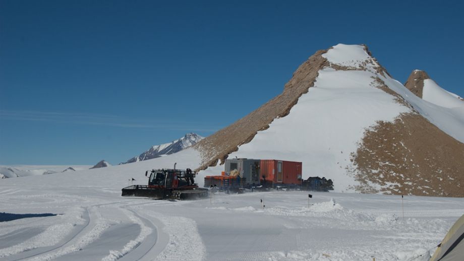
A pyramid-shaped mountain (Figure 1) in Antarctica has sparked speculation among social media users who are sharing claims that it is not natural, but rather a pyramid built by an ancient civilization. Although the mountain does have some visual similarities to a pyramid – e.g., having a peak and four sides – there are several clues and lines of evidence indicating that this is a natural mountain peak, as we will detail below.

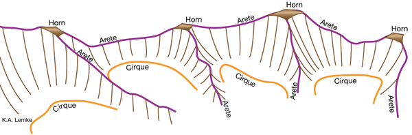
Although this mountain is particularly pyramidal, the shape itself is not rare. Peaks with similar shapes exist around the world and geologists have studied these to understand the natural processes that form them – a field of study called geomorphology. Geologists refer to these types of peaks as ‘horns’ – examples include the famous ‘Matterhorn’ in Switzerland, and the lesser known ‘Alpamayo’ mountain in Peru (Figure 2).

As described in the United States Geological Survey Glossary of Glacier Terminology, horns are “a pointed, mountain peak, typically pyramidal in shape, bounded by the walls of three or more cirques . . . when a peak has four symmetrical faces, it is called a Matterhorn”. Cirques are hollow areas carved into mountains as glaciers move downward and erode (i.e., remove) underlying rock[1]. The intersection of multiple cirques leaves behind a peak (i.e., horn) connected to 3 or 4 ridges – marking the outer boundaries of where the glaciers eroded, as shown in Figure 3 below.
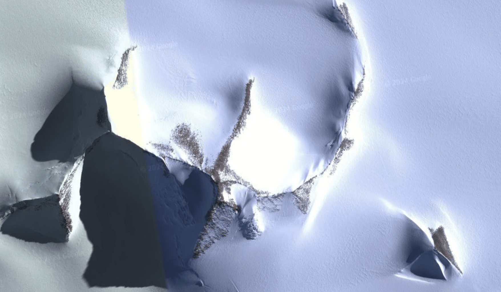
There is clear evidence of past glacial erosion in this region of Antarctica[2]; however, in some areas, snow and ice cover many of the lower landscape features that make this more apparent. Note that the examples in Figure 2, which are not covered by ice sheets, show less of a pyramidal shape near the base of these mountains. However, the pyramidal peak (Figure 1) shown in social media videos is largely covered in snow and ice, covering many of the landscape features near its base that would likely make it easier to identify as a glacial horn. For this reason, sometimes other observations and information must be gathered from the surroundings to characterize geologic features. This is something that we discussed in a similar past Science Feedback review, linked here. So what do the surroundings tell us?
The horn-formation process we described above occurs in cold, glaciated environments, such that of the Ellsworth Mountains of Antarctica where the pyramidal horn is located. Thus, its location matches the environment where this type of peak forms. In fact, this process of glacial erosion is common in Antarctica as evidenced by the number of horns and pyramidal peaks nearby (Figures 4-6). Many pyramidal peaks are documented in a report titled “Geographic Names of the Antarctic” including Abbott Peak, Achilles Mountain, and several others.

Overall, the peak’s physical characteristics, surrounding glacial environment, and proximity to a number of other pyramidal peaks with similar patterns of glacial erosion, is strong evidence that the pyramidal feature shown in viral social media videos is a natural mountain peak – called a pyramidal peak or horn – formed over time through glacial erosion. Additionally, there is no record of an ancient civilization or any constructed pyramids in Antarctica, which has been surveyed since the early 1900s.
Antarctica slowly moved to its current position over millions of years; no evidence of rapid shift
A number of viral clips on social media feature Billy Carson speculating about Antarctica’s past. In these videos, Carson claims that ‘Antarctica quickly shifted into its current position on Earth through tectonics and sudden crustal pole shift’. Carson suggests that these two concepts somehow work together; however, they are actually incompatible and only one of them – plate tectonics – is supported by scientific evidence and widely accepted by geology experts[3], as detailed below.
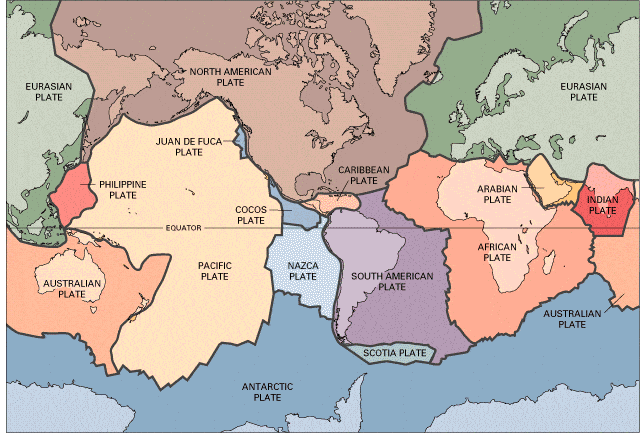
As described in Palin and Santosh (2021), “the theory of plate tectonics is widely accepted by scientists and provides a robust framework with which to describe and predict the behavior of Earth’s rigid outer shell – the lithosphere – in space and time”[3]. This well-accepted theory explains that Earth’s outer shell is broken up into different tectonic plates, like a giant jigsaw puzzle (Figure 7), which move around very slowly – i.e., a few centimeters per year[4], or as the USGS explains, roughly at the same rate that your fingernails grow.
Over millions of years, they can carry their overlying continents to different positions on Earth’s surface, and thus sometimes to different climates. Together, these concepts describe the widely accepted theories of plate tectonics and continental drift. In conjunction with past climate variations, these concepts help explain why icy regions (e.g., Antarctica) show geologic evidence of different conditions in their past (e.g., being in warmer climates). Contrary to the universally accepted theories above, some have speculated a ‘cataclysmic pole shift’, caused these climate changes due to rapid shifts in Earth’s crust and poles. However, this does not match the scientific evidence. For example, researchers have studied past shifts in Earth’s poles spanning 160 million years and they explain that the evidence does not support the ‘rapid’ or ‘massive’ polar shift being claimed[5].
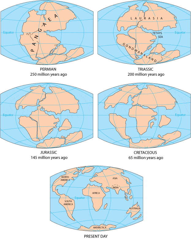
Scientific evidence also does not support a rapid shift in Antarctica’s position – a claim suggested in social media videos. Instead, evidence shows that Antarctica began slowly moving to its current position roughly 182 million years ago[6,7]. At that time it was part of a larger supercontinent called Gondwana (Figure 8) – which also included land that we now call South America, Africa, Madagascar, India, Western Australia, and Arabia[7]. To emphasize how slow this transition was, it’s worth noting that East Antarctica and Australia only split from each other around 85 million years ago[7] – 97 million years after Antarctica began separating from Gondwana.
Conclusion
There is no evidence of an ancient civilization, nor any pyramids in Antarctica, contrary to claims from viral videos on social media. There are, however, several pyramid or semi-pyramid shaped mountains called ‘horns’ or ‘pyramidal peaks’, which form through glacial erosion. These peaks are well-documented in Antarctica and many other glaciated areas around the world, such as Switzerland and Peru. Contrary to other claims made in these videos, Antarctica did not experience a sudden change in climate due to a sudden shift in the poles or Antarctica’s position on Earth. Scientific evidence shows that Antarctica slowly drifted to its current position over millions of years through tectonic plate movement.
REFERENCES
- 1- Hess (2016) McKnight’s Physical Geography: A Landscape Appreciation.
- 2 – Sugden et al. (2017) The million-year evolution of the glacial trimline in the southernmost Ellsworth Mountains, Antarctica. Earth and Planetary Science Letters.
- 3 – Palin and Santosh (2021) Plate tectonics: What, where, why, and when?. Gondwana Research.
- 4 – Zahirovic et al. (2015) Tectonic speed limits from plate kinematic reconstructions. Earth and Planetary Science Letters.
- 5 – Kulakov et al. (2021) Jurassic fast polar shift rejected by a new high-quality paleomagnetic pole from southwest Greenland. Gondwana Research.
- 6 – Moulin et al. (2011) An attempt to constrain the age, duration, and eruptive history of the Karoo flood basalt: Naude’s Nek section (South Africa). Journal of Geophysical Research: Solid Earth.
- 7 – Svensen (2018) Gondwana Large Igneous Provinces: plate reconstructions, volcanic basins and sill volumes. Geological Society, London, Special Publications.


